Professional avalanche safety programmes to protect the public require battlefield-like tactics based on precise observations and meticulous research. Locating the danger, understanding the hazard, and assessing the risks are critical strategies. While history has shown that avoidance is the safest strategy, there are times and places for defence and attack.
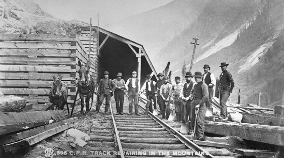
Battle TacticsProfessional surveyors and engineers working for the Canadian Pacific Railway studied avalanche activity in the 1880s along the route of Canada's first transcontinental railway.
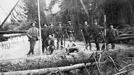
Civil engineers pioneered avalanche study in Canada during the winters of 1884-85 to 1886-87.
There are no known photographs of their winter avalanche and snow observation camps. BC. 1885. © Glenbow Archives NA-4428-8.
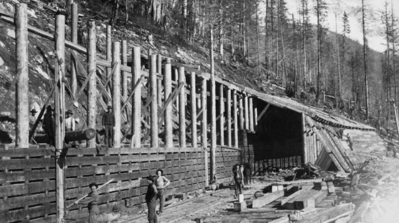
Observing avalanche activity allowed railway engineers to locate and design avalanche defences such as this side hill snowshed.
East of the summit of Rogers Pass, Glacier National Park, BC. ca 1886-88. © Glenbow Archives NA-4428-16.
The CP Railway pioneered avalanche research to help locate and design avalanche defences for the nation's first transcontinental railway.
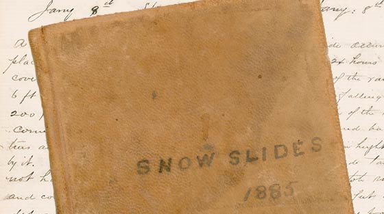
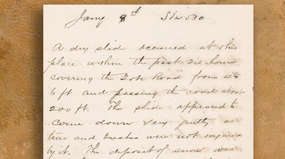
Detailed records from snow camps in the Selkirk Mountains allowed Canadian Pacific Railway to draw up its first avalanche battle plan. Image I/CM/Sy4 courtesy of Royal BC Museum, BC Archives.
S.A. Sykes's notebook,1885.
S.A. Sykes and his colleagues made the first systematic avalanche observations in Canada. Selkirk Mountains, BC 1885. Image I/CM/Sy4 courtesy of Royal BC Museum, BC Archives.
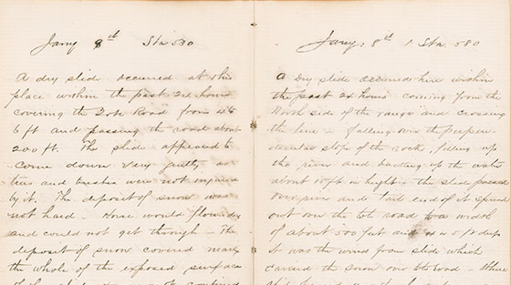
Close-up section of S.A. Sykes's notebook,1885.
Image I/CM/Sy4 courtesy of Royal BC Museum, BC Archives.
Snow study tools invented by Canadian George Klein were adapted to avalanche research in Rogers Pass in the days leading to the completion of the Trans-Canada Highway.
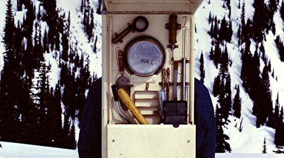
Snow science tools developed rapidly with the decision to route the Trans-Canada Highway through Rogers Pass in the mid-1950s.
Noel Gardner carrying a portable snow research kit used in Rogers Pass, Glacier National Park, BC, 1963. Revelstoke Museum & Archives 5540. © Betty Gardner Collection
Transcript Download MP4 (53.6 MB) Download WEBM (40.1 MB)
The Klein snow study kit was invented by Canadian George Klein in the 1940s while he was working for the National Research Council.
After the highway opened in 1962, Noel Gardner led the avalanche safety team until 1965. Revelstoke Museum & Archives A2013.22.2 © Government of Canada, Bruno Engler.
Transcript Download MP3 (1:02 0.9MB) Download WAV (1:02 0.7MB)
“In order to do this type of work… you simply have to know avalanches and go out in the field…and get a good feeling about what they do.”
Avalanche expert Peter Schaerer talks to Cathy English, Curator of Revelstoke Museum & Archives, about what it takes to make an avalanche expert. Revelstoke, BC, 2009. Revelstoke Museum & Archives A2013.30
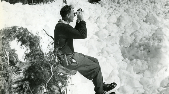
A leader in Canadian avalanche research for more than 50 years, Peter Schaerer was awarded the Order of Canada in 2000.
Peter Schaerer using an inclinometer to measure slope angle of an avalanche path in Rogers Pass. Glacier National Park, BC, 1958. © Revelstoke Museum & Archives PSA.58. © Public Works Canada, Bruno Engler.
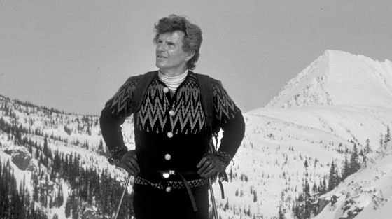
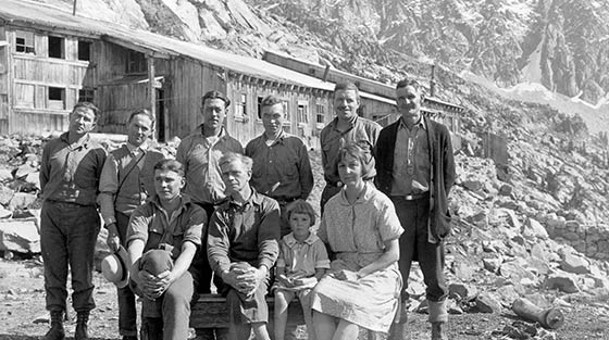
Fred (V.G.) Schleiss received a life-time achievement award from the Canadian Avalanche Association in 2007.
A leader in developing observational techniques, Schleiss led the avalanche safety team in Rogers Pass from 1965-1991. Summit of Balu Pass, Glacier National Park, BC, circa 1980. Revelstoke Museum & Archives 5542. © Parks Canada, John G Woods.
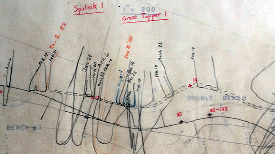
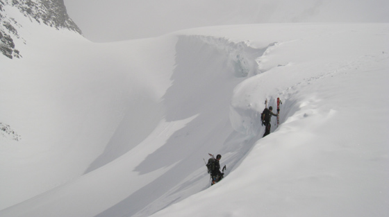
Meticulous field observations combined with rigorous record-keeping are essential in avalanche safety planning.
This plan records avalanche activity along the proposed route of the Trans-Canada Highway over Rogers Pass. Today there is a snowshed in this area. Glacier National Park, BC, 1958. © Revelstoke Museum & Archives 5543.
Avalanche observers continue to adapt snow-craft tools combining time-honoured instruments with modern materials such as waterproof notebooks and dial thermometers.
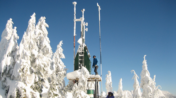
Since 1991, avalanche professionals share their weather and avalanche observations on a continuous basis throughout the avalanche season.
The Canadian Avalanche Association runs the InfoEx© data exchange accessible for subscribing professionals. Great Bear weather station, Coquihalla, BC, 2007. Revelstoke Museum & Archives 5341. © BC Ministry of Transportation and Infrastructure.
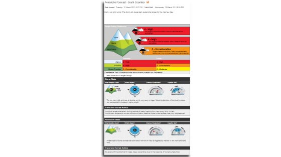
Daily avalanche forecasts are available to the public on Avalanche Canada's website www.avalanche.ca
Issued by Avalanche Canada on Tuesday, 12 March 2013. Revelstoke Museum & Archives 5541. © Avalanche Canada.
Armed with knowledge of when and where avalanches are likely to strike, avoiding slidepaths during their dangerous season is often the best safety strategy. This is true for all activities in avalanche country from community planning to backcountry recreation. If paths must be crossed, then minimizing exposure time is often the next best option.
Avalanche no-stopping zones reduce exposure to avalanche hazard. Trained backcountry recreationists use the same principle to reduce risk.
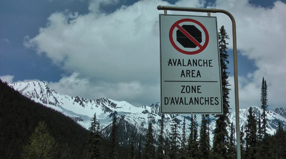
Avalanche area no-stopping signs identify danger zones along highways and warn motorists to keep moving.
Avalanche area no-stopping sign. Trans-Canada Highway, Rogers Pass, Glacier National Park, BC, 2010 Revelstoke Museum & Archives 5336. © Parks Canada.
People travelling through avalanche country on their own must be able to identify danger zones and the safest travel routes.
Near Fairy Meadows, Selkirk Mountains, British Columbia 2009, Revelstoke Museum & Archives 5544. © Fraser Sprigings.
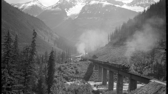
The Canadian Pacific Railway avoided extreme avalanche exposure on the western side of Rogers Pass by lengthening the line in a series of loops.
This train is looping its way into Rogers Pass while avoiding the extreme avalanche hazard on Mount Cheops to the left. Glacier National Park, BC, circa 1910. © Whyte Museum NA-71-1636.
In 1916, the Canadian Pacific Railway avoided most of the avalanche danger in Rogers Pass with the opening of the Connaught Tunnel.
The tunnel shortened the line, reduced the grade, and made many snowsheds obsolete. Rogers Pass, Glacier National Park, BC, circa 1916. © Glenbow Archives NA-4598-3.
In 1988, the Canadian Pacific Railway further reduced its avalanche exposure in Rogers Pass with the opening of the Macdonald and Shaughnessy tunnels.
The inauguration train emerges from the Mount Shaughnessy Tunnel, May, 1989. Glacier National Park, BC. © Canadian Pacific Archives E6664.
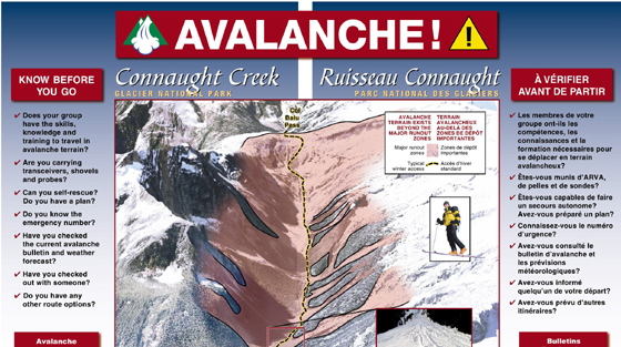
Today, avalanche maps identify hazards and are used in transportation, industry, and recreation to increase public and workplace safety.
This map of avalanche terrain is provided to backcountry recreationists to help in route planning. Similar maps are available for other areas. Glacier National Park, BC, 2013. Revelstoke Museum & Archives 5337. © Parks Canada.
Snowsheds have been part of the yearly battles with avalanches in Canada since the winter of 1886-87. To be effective, the sheds need to be well-placed and built to withstand sudden hurricane-force winds mixed with snow. They also need the strength to support the weight of settled avalanche debris. Avalanche activity after construction often showed that the sheds needed to be revised—most often lengthened.
History of Snowsheds
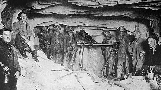
Pioneer mining used snowsheds to protect buildings and the tramways that were used to carry ore.
9 people died in an avalanche at the Molly Gibson Mine on Christmas night, 1902. This photograph was likely taken several years later. Selkirk Mountains, BC. © BC Archives D_06525.
An extensive system of snowsheds once protected the Canadian Pacific Railway in Rogers Pass. Some are still used in other areas along the line.
Massive cribbing anchors 11 Shed to the side hill. The strongly supported roof conformed to the slope of the avalanche path above. Glacier National Park, BC, 1886. © Canadian Pacific Archives a7634
Transcript Download MP3 (0:54 1.2MB) Download OGG (0:54 0.7MB)
“Finally we found one spot that we all of a sudden could see the snowshed… we could just get in there. We hollered in and people answered… and there were two families in there”
Avalanche forecaster Walter Schleiss describes the rescue of two families trapped in Lanark Shed on the Trans-Canada Highway, BC. After eight hours, they were rescued unharmed. January 1st, 1963. © Revelstoke Museum & Archives A2013.9
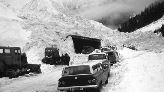
Snowslides overwhelmed both ends of Lanark Shed on the Trans-Canada Highway during its first winter of use.
Provincial and National Park highway crews worked together to release the trapped families. Retaining walls were added to the shed to prevent future spill-over. BC,1963. Revelstoke Museum & Archives 5332. © Parks Canada.
Transcript Download MP4 (17.2 MB) Download WEBM (11.6 MB)
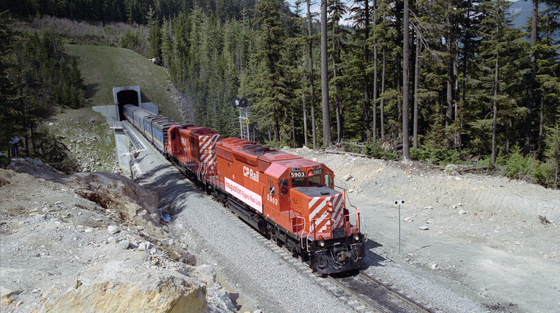
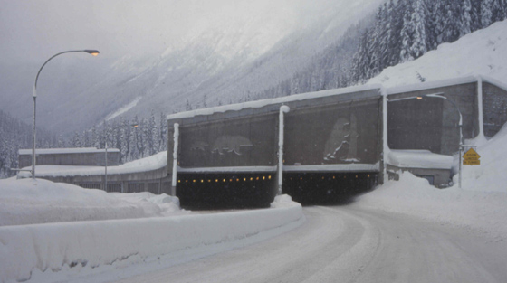
Driving through the Great Bear Snowshed on the Coquihalla Highway in BC. Millions of people drive through snowsheds in Canada each year.
If you have never driven through a snowshed, here is your chance; a front seat view from a passenger bus passing through the Great Bear snowshed on the Coquihalla Highway (Hwy 5), BC, 2012. In winter, the sheds protect thousands of people daily as they cross avalanche paths. Revelstoke Museum & Archives A2013.16.2. © John G Woods.
Canada's newest highway snowshed, the Great Bear, started protecting travellers during the winter of 1986-87.
This snowshed on the Coquihalla Highway (Hwy 5) is Canada's newest snowshed. 8 others are located on the Rogers Pass route (Hwy 1) between Revelstoke and Golden, BC, date unknown. Revelstoke Museum & Archives 5339. © BC Ministry of Transportation and Infrastructure.
Explosives are routinely used in many avalanche areas in Canada to trigger slides under controlled conditions. With the slopes safely stabilized, the closed areas are re-opened.
Artillery fire can allow avalanche control around the clock during any weather.
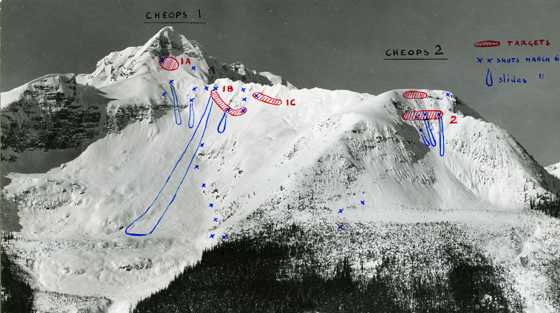
Avalanche professionals keep meticulous records of success and failure in the never-ending war with snow.
Firing targets and resulting avalanches in Cheops 1 and Cheops 2 slidepaths at the summit of Rogers Pass, Glacier National Park, BC. March 6, 1958. Revelstoke Museum & Archives PSA.89. © Government of Canada.
Transcript Download MP4 (39.1 MB) Download WEBM (26.8 MB)
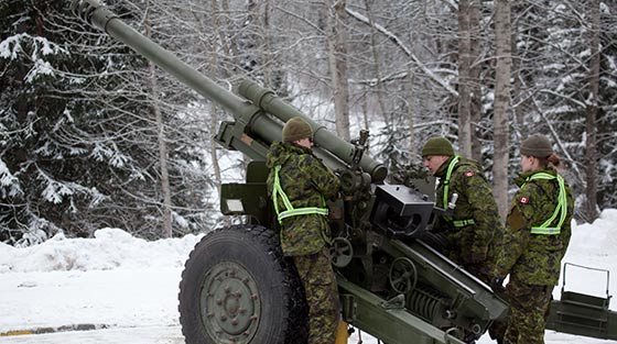
Precision bombardment with 105 mm Howitzers provide avalanche control around the clock during any weather in Rogers Pass.
Working with Parks Canada, the Canadian Armed Forces fires a 105mm C3 Howitzer in Rogers Pass. Precision blind-firing enables avalanche control whenever required. Glacier National Park, BC. 2013. Revelstoke Museum & Archives A2013.16.7.
Today, explosives are routinely used to release or stabilize snowpacks before avalanches can strike without warning.
Aligning the artillery for an avalanche control operation along the Trans-Canada Highway in Rogers Pass, Glacier National Park, BC, 2012. Revelstoke Museum & Archives P5567. © Parks Canada Rob Buchanan.
Explosives dropped from helicopters offer precise delivery and close observation of resulting slides.
Transcript Download MP4 (20.2 MB) Download WEBM (18 MB)
A helicopter drops explosives to trigger avalanches above B.C. Hwy. 3 in Kootenay Pass, spring 2012.
Spring 2012, Kootenay Pass. © BC Ministry of Transportation and Infrastructure. Revelstoke Museum & Archives A2013.24.3.
Gas exploders offer remote-controlled avalanche stabilization.
Transcript Download MP4 (27.9 MB) Download WEBM (18.5 MB)
Footage of an avalanche triggered by remote control Gazex exploders, above B.C. Hwy. 3 in Kootenay Pass, BC.
Spring 2012, Kootenay Pass. © BC Ministry of Transportation and Infrastructure. Revelstoke Museum & Archives A2013.24.3
Transcript Download MP4 (14.8 MB) Download WEBM (10.8 MB)
Jim Bay, avalanche professional with AvaTech Mountain Systems Inc. demonstrates the DaisyBell avalanche control system.
Footage taken from a helicopter in the Selkirk Mountains. © Jim Bay, AvaTech Mountain Systems. Revelstoke Museum & Archives A2013.32.2
Hand-thrown charges are used to stabilize slopes at many ski resorts.
Transcript Download MP4 (20.2 MB) Download WEBM (18 MB)
Avalanche technicians at Revelstoke Mountain Resort prepare and conduct a hand-bombing procedure.
Revelstoke Mountain Resort. © Revelstoke Mountain Resort, BC. Revelstoke Museum & Archives A2013.32.1